GurwinderKaur
Hagibis was the strongest storm of the year to hit Japan, landing again at high tide causing heavy damage.
Typhoon Hagibis hit Japan on the evening of October 12, causing record rainfall in the past six decades in the country. At least 35 people were dead, 20 were missing and dozens were injured. The storm also left 425,000 households without electricity.
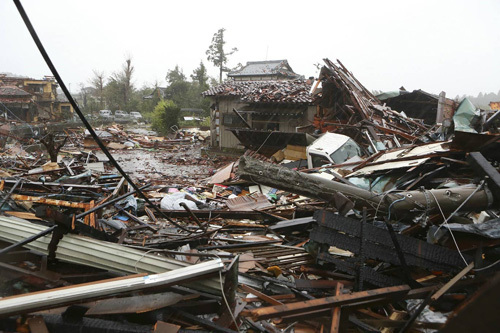
Houses destroyed by Typhoon Hagibis in Chiba Prefecture, east of Tokyo on October 13 Photo: AFP
Here are four reasons why Hagibis is so devastating.
In terms of size, Hagibis has areas of cloud cover. The diameter of the strongest wind region with a velocity of more than 54 km / h is 1,400 km, nearly half the length of the Japanese archipelago. Due to its sheer size, storms will start earlier, last longer and affect larger areas.
Hagibis has a central pressure of 915hPa on 10/10, making it the most intense tropical storm in 2019. As the storm strengthened rapidly near the northern Mariana Islands, the central pressure dropped sharply from 992hPa to 915hPa within 24 hours.
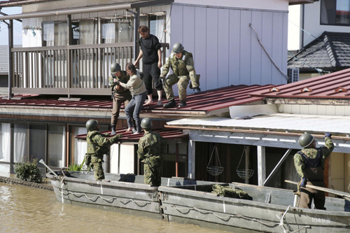
Japanese Self-Defense Forces soldiers evacuated people from flooded areas after Hagibis in Miyagi Prefecture on October 13 Photo: Reuters
The Japan Meteorological Agency (JMA) said the storm reached 950hPa when it landed. According to Digital Typhoon, this is the ninth fastest rising storm in recorded history.
What caused Hagibis to inflict more damage was also due to the typhoon landing near the day of the full moon, meaning that the sea level was higher than normal. The combination of high tides, high waves and storm surges caused severe flooding in eastern and central Japan.
Hagibis is also the second "blow" to the greater Tokyo area within a month. In early September, Typhoon Faxai struck the area with winds of 207 km / h in Chiba Prefecture, east of Tokyo. At least three people have been killed, hundreds of thousands of households have suffered power outages and many homes have been damaged.