Ricardo DA Figueiredo
The satellite image shows a 100-meter-wide crater formed in the port of Beirut, after an explosion of more than 2,700 tons of ammonium nitrate on August 4.
A satellite image taken by Planet Labs, a private company based in San Francisco, USA, shows that nearly every building in the area of the explosion in the port of Beirut, the capital of Lebanon, has been completely leveled.
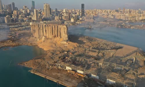
The scene was devastated at the port of Bierut after the explosion on August 4 Photo: CNN/Planet Labs
CNN used geospatial software to measure the size of the crater and determine it had a diameter of 124 meters.
According to satellite images, buildings in the south of the harbor are seriously affected.
The damage of the explosion also spread to a peninsula in the east, where a building was blown away and a ship seemed to be flipped over.
According to Lebanese Prime Minister Hassan Dia, the disaster occurred on August 4 due to the explosion of 2,750 tons of ammonium nitrate.
At least 135 people have been killed and over 5,000 injured.
The Lebanese government has declared a two-week emergency in Beirut, requiring the military to house arrest all officials in charge of goods storage and security in Beirut port since 2014.